

Sabah looks small on a world map, but once you start planning a trip to famous places, the distances surprise you 😊. A peta Sabah shows you more than borders and town names. It shows you why a trip to the east coast needs a flight, why the west coast is so easy to base yourself in, and why you can’t squeeze everything into three days.
I will explain how to read the map of Sabah, what each region offers, and how to connect the places you want to see.
Where Sabah Sits on the Map
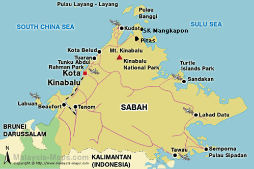
Sabah occupies the northern tip of Borneo. It is Malaysia’s easternmost state and the second largest after Sarawak, which lies to its southwest. To the south, Sabah shares a land border with Indonesian Kalimantan.
The South China Sea runs along its western and northern coastline. On the east side, you face the Sulu and Celebes Seas. Locals call Sabah the Land Below the Wind, because it sits just south of the typhoon belt.
The easiest way to picture the state is as two coasts separated by a mountain spine. The west coast is busier, more developed and easier to reach. The east coast is wilder, with rainforest, rivers and the best marine areas in the state.
The Five Divisions on the Sabah Map
Most Sabah maps are divided into five administrative divisions. Knowing them helps because tour itineraries, road signs and transport timetables often refer to them.
West Coast Division
Is where most visitors land. It includes Kota Kinabalu, Penampang, Putatan, Papar, Tuaran, Kota Belud and Ranau.
Interior Division
Covers the highland and valley districts such as Keningau, Tambunan, Tenom, Beaufort, Sipitang and Kuala Penyu.
Kudat Division
Sits at the northern tip. It is the smallest division by area, and includes Kudat, Kota Marudu and Pitas.
Sandakan Division
It is the largest, covering more than a third of the state. Sandakan town, Beluran, Kinabatangan and Tongod fall within it.
Tawau Division
It is in the southeast and includes Tawau, Lahad Datu, Kunak, Kalabakan and Semporna.
Altogether, Sabah has more than two dozen districts. You don’t need to memorise them, but a few names will come up again and again while you plan.
Kota Kinabalu and the West Coast
On any peta Sabah, Kota Kinabalu is the obvious starting point. It is the state capital, the largest city, and home to Kota Kinabalu International Airport. Most travellers arrive here and stay at least a night.
The city itself is compact. You can find waterfront markets, mosques, cafes, shopping malls and colonial-era buildings along Gaya Street. Just offshore, the islands of Tunku Abdul Rahman Park are a short boat ride from the jetties, which makes island hopping an easy half day or full day.
Look slightly further out on the map and the west coast opens up:
Tuaran and Kota Belud, to the north, for river cruises, Bajau culture and Sunday markets.
Papar and Putatan, to the south, for beaches and local food.
Ranau, inland to the east, where Kinabalu Park and Mount Kinabalu are located. The drive from the city takes around two hours, depending on traffic.
If you only have a short trip, the west coast alone can fill a week without much backtracking.
The Interior and the Far North
Move inland on the map and you reach the Interior Division. Tambunan, Keningau and Tenom are cooler, greener and less visited. They suit travellers who want mountain scenery, village stops and a slower pace.
Go north and the map narrows towards Kudat, where the Tip of Borneo marks the northern end of the island. The road there is long, usually three to four hours from Kota Kinabalu, so most people treat it as an overnight trip. Beaches, rice fields and longhouse communities along the way make it worth the effort.
The East Coast: Sandakan, Kinabatangan and Tawau
Look at the east side of your peta Sabah and you will notice how far everything is from the capital. This is where the state’s wildlife is concentrated.
Sandakan is the main gateway, with the Sepilok area known for orangutan rehabilitation and sun bear conservation. A short distance south, the Kinabatangan River is one of the best places in Borneo for river cruises and wildlife spotting.
Further southeast, Lahad Datu leads toward Danum Valley and other protected rainforest. Semporna island is the base for the islands and dive sites, including Sipadan, which draws divers from around the world.
How Far Is Everything?
This is the part many people get wrong. The map makes distances look short, but road conditions and mountain terrain slow things down.
A flight from Kota Kinabalu to Sandakan takes about 40 minutes and runs several times a day. Driving the same route can take seven to eight hours.
From Tawau to Semporna, it is roughly an hour and a half by road. Many divers fly straight from Kota Kinabalu or Kuala Lumpur to Tawau, then continue by car.
A simple rule works well. Use the road on the west coast and to Kinabalu Park, and use flights to reach the east coast.
Sample Routes Based on the Map
If you are short on time, these combinations work well:
- 3 to 4 days: Kota Kinabalu, island hopping in Tunku Abdul Rahman Park, and a day trip to Kinabalu Park.
- 5 to 6 days: add a flight to Sandakan for Sepilok and a Kinabatangan river stay.
- 7 to 10 days: add Kudat and the north, or Semporna and the islands, depending on whether you prefer beaches or diving.
Try not to place too many bases on your plan. Two or three overnight stops is usually enough for a comfortable trip.
Planning Your Own Route Around Sabah
Once you understand the map, the next question is how to get between the places you picked. Public transport covers the main towns, but it doesn’t reach many of the attractions, and timetables don’t always match tour schedules.
If you would rather skip the driving, City MPV Travel and Tours is a licensed tour operator based in Kota Kinabalu. They run airport pickups, private MPV transfers and day trips across the west coast, along with island hopping and Mount Kinabalu packages. For travellers with a tight schedule, a private vehicle and a local driver means you spend your time at the destination instead of studying road maps.
Questions Asked by People About the Sabah Map
How many divisions does Sabah have?
Five: West Coast, Interior, Kudat, Sandakan and Tawau.
What is the capital of Sabah?
Kota Kinabalu, on the west coast. It was formerly known as Jesselton.
Which part of Sabah is best for first-time visitors?
The west coast. It has the airport, accommodation, island trips and Mount Kinabalu within a few hours of each other.
How do I travel between the west and east coasts?
Flying is the most practical option. The drive between Kota Kinabalu and Sandakan takes most of a day.
Is Sabah part of Borneo?
Yes. It sits on the northern part of the island, alongside Sarawak, Brunei and Indonesian Kalimantan.